Wondering where to hike for the best places on Vancouver Island?
We got you covered with the top 10 hikes of Vancouver Island.
Whether you want to wander a beach trail, climb a mountain or follow a stream, here are the top 10 hikes on Vancouver Island, in no particular order.
West Coast Trail
This is the most difficult and likely the most spectacular trail.
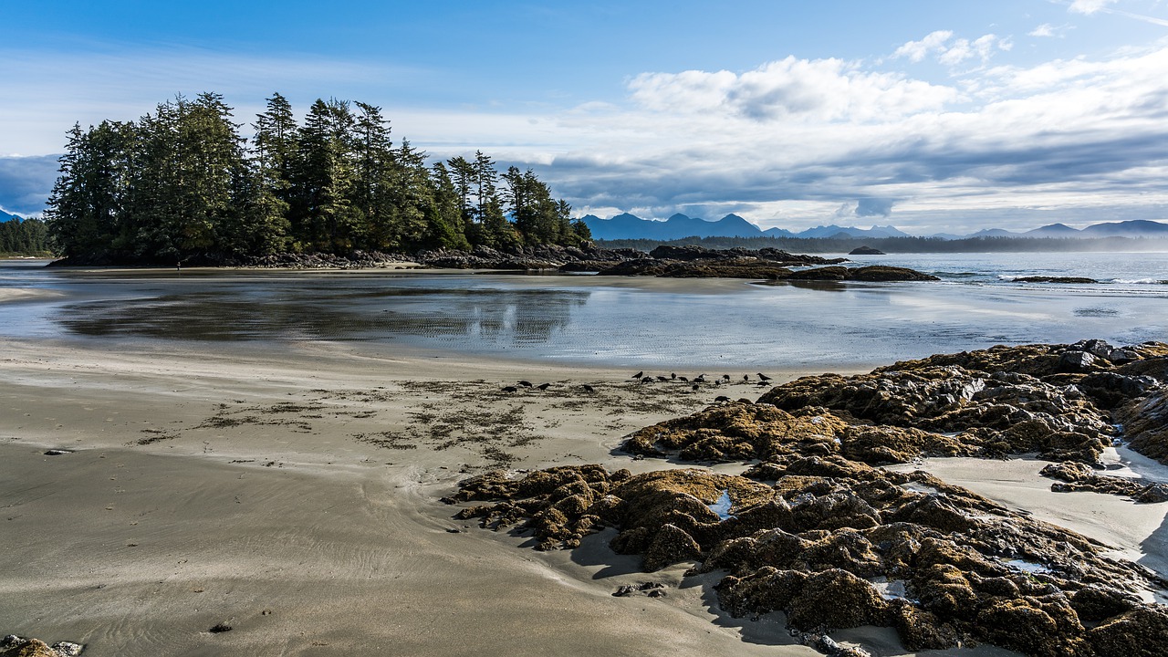
The West Coast Trail is one of the most famous hiking trails in all of Canada.
Hikers come for the scenery and the challenge, to say they hiked the trail.
That’s because it’s a difficult hike that takes 5-7 days to complete, longer for people who are slower.
The trail stretches 75 kilometers, from south of Port Renfrew to Bamfield, and can be done in either direction.
You will need to carry a 40-50 lb. pack with all your gear and expect to encounter all kinds of terrain, with forests, bogs, beaches, rocky headlands and more. Hikers need to climb ladders and other obstacles, stumble over slippery rocks, risk hypothermia and endure torrential downpours at times.
Good preparation is extremely important.
The West Coast Trail is open from May 1 to Sept.30 and you need a permit. The reservation system opens in early January and spaces fill almost immediately so be fast.
Check with the Pacific Rim National Park Reserve site for details and planning.
Juan de Fuca Marine Trail
The Juan de Fuca Marine Trail, usually just called the Juan de Fuca Trail, is another trails that takes several days to complete.
While it’s not as intense as the West Coast Trail, it still has its challenges. It runs from China Beach to Port Renfrew and takes hikers along open stretches of beautiful beaches, over rugged shorelines, through forests of huge Sitka spruce, western hemlock and western red cedar.
Those less ambitious can do a day hike along the Juan de Fuca Trail.
The trail can be accessed from different points, such as China Beach, Sombrio Beach or Port Renfrew near Botanical Beach.
The beaches all have something different to offer;, Port Renfrew offers a stroll through a dense forest with towering trees, Sombrio has ocean front campsites while China Beach is one of the most beautiful and easily accessible. The trail only leads through the woods from the parking lot so you have to detour a bit to see China Beach.
3. Cathedral Grove (McMillan Provincial Park)
Most people drive through it on their way to the west coast yet this 301 hectare park is one of the most accessible stands of old growth giant Douglas fir trees in the province. More a stroll than a hike, visitors can meander through a network of trails under the trees, some which are more than 800 years old. Yep, you read that right.
The park was established in 1947 and trails on either side of the highway lead visitors through the forest. The south side features the largest Douglas firs, including one that measures more than 9 metres in circumference. That’s 30 feet!
The north side has groves of ancient Western red cedar looking over nearby Cameron Lake, a great spot for camping, swimming, boating or picnics.
A severe windstorm in toppled huge trees in 1997, however their value has not diminished as these fallen trees open up the area and provide light, space, shelter and nutrients for the next generation.
The park’s small size and accessibility has left it vulnerable to impacts from high visitor use. Please stay on designated trails, where you will find ample opportunities to view and photograph this bit of history.
Special Features: The park protects and preserves an internationally significant example of Douglas fir old-growth forest within the Coastal Western Hemlock Biogeoclimatic Zone.
Get to the park early in summer as parking spaces can get full by midday.
Wild Pacific Trail – Ucluelet
One of the best trails to explore on the west coast is the Wild Pacific Trail.
It starts at the lighthouse at the southern end of Ucluelet and winds along the coast providing stunning vistas, little coves and private beaches.
The trail offers a glimpse of the wild and rugged coast that dominates the western shores of Vancouver Island. Hikers can see offshore islands, waves crashing on rocks, as well as twisted and windblown trees that have a wild unique beauty.
The trail has two sections. The Lighthouse Loop is a 2.6-kilometer trail and the most popular with the most stunning scenery. Brown’s Beach to Rocky Bluff is an eight-kilometer return-trip hike along the ocean and through rainforest and is also worth doing.
It is possible to do both in one day but you’ll need to start early.
San Josef Bay – Cape Scott Provincial Park
If you can make it to the far north of Vancouver Island, you’ll be rewarded with the ruggedly beautiful and little visited Cape Scott Provincial Park.
Set along the remote western shore, it is about an eight-hour drive north of Victoria and a 4.5-hour drive north of Campbell River.
There’s not much out there other than forest and a couple small towns.
Cape Scott Provincial Park offers access to some dramatic scenery and wonderful hiking trails. The San Jose Bay Trail is an easy five-kilometer round-trip hike, which takes you out to the bay, which is an area of beach, rocky shoreline with tidal pools, and sea stacks. It’s these sea stacks that can make for some stunning photography.
So it’s not much of a hike but worth visiting for its unique, wild beauty.
Bring a lunch and make a day of it, exploring small shore caves at low tide and appreciating the remoteness and solitude.
As San Josef Bay is about a two-hour drive from Port Hardy, you might want to plan a San Josef Bay Tour if you are staying in the town. Transport is provided from Port Hardy to Cape Scott Provincial Park and includes this hike.
Those who want a more advanced trail should consider the 23 km one way Cape Scott Trail, or the or the North Coast Trail, a 43-kilometer add-on to the Cape Scott Trail.
Both of these are in Cape Scott Provincial Park and are for advanced hikers who are familiar with coastal conditions in this area. The North Coast Trail requires a minimum of five days, but hikers should prepare for seven to eight days to complete.
Elk River Trail
The Elk River Trail is 11 kilometers, with 600 meters of elevation, and it is one of the most popular and beautiful hikes in the Strathcona Provincial Park.
The park is just a 45-minute drive from Campbell River, in North Central Vancouver Island.
The trail takes you up the Elk River Valley to scenic Landslide Lake , where surrounding mountains are reflected in the aquamarine waters of the lake. If you want to do this hike as a two-day trip, camping is available at Butterwort Flats, six kilometers from the start, or at the upper gravel bar campsite, nine kilometers in. There is no camping at Landslide Lake, which is an in-and-out hike.
Paradise Meadows –Helen Mackenzie/Battleship Lake
Paradise Meadows has become a very popular day trip with a loop that takes in Battleship Lake and Lake Helen Mackenzie.
There are boardwalk trails, with some that are wheelchair accessible. The sub-alpine area offers beautiful scenery with colorful wildflowers in the summer. Whiskey Jack birds willingly take food from your hands near Battleship Lake.
A good way to start is to stay to the left and go past Battleship Lake first – it has some rock areas overlooking the lake to enjoy a snack or lunch, then a dip in the lake. The trail continues uphill and then go by Lake Helen Mackenzie, a glacier fed lake which is very cold, even in summer.
The loop is 6.8 km and takes about 2.5 hours. Those who want a longer hike can continue into the back country and backpack or camp in the area at designated platforms.
This sub-alpine area offers some beautiful scenery and comes to life with colorful wildflowers during the summer. The trailhead is located at the Mount Washington Ski area. The chair lift is available during the summer for rides to the top and the village has plenty to offer with restaurants, hotels and other activities.
Mount Benson Regional Park
The challenge of climbing Mount Benson is one locals like to boast they have completed.
The park is 213 hectares of forested land along the upper north-east slopes of Mount Benson. It has amazing panoramic views extending from Nanaimo to the Strait of Georgia, towards the mainland and beyond. Hikers may go past Witchcraft Lake on their way up the mountain.
Rugged mountain trails and old logging roads allow users to explore the park and reach the summit of Mount Benson. The summit is located outside park boundaries and provides stunning views towards Nanaimo and the Strait of Georgia. Trails are steep and rough; allow 5 to 7 hours for a return trip and be prepared for changeable weather.
Newcastle Island Provincial Park
This popular park is reached by foot passenger ferry at the end of Maffeo Sutton Park near downtown Nanaimo. A trail circles the entire island with wonderful views and beaches along the way. The counter clockwise route takes hikers past the island campgrounds, around Brownie Bay, a charming place to enjoy the beach or swim, then continues to Kanaka Bay, goes up to a lookout at Mckay Point, continues to Giovando Lookout where one can see ferries coming in or out of Departure Bay, and continues along to Shaft Point and Midden Bay.
There is an ancient mine shaft near here. Hikers will continue along a Sandstone Quarry, then follow the trail around Mark Bay and go past the Pulpstone Quarry. There is much history in the park which can be read at the pavilion where there is also a concession.
The rambling 8 km. trail around the island is fairly easy and takes about 2 km. depending how many stops one takes. Make a day of it and take a lunch or visit the pavilion.
Cowichan Valley Trail
The Cowichan Valley Trail is an awesome multi-use trail that is an integral part of the TransCanada Trail route on Southern Vancouver Island. The Cowichan Valley section runs from the Capital Regional District boundary at the top of the Malahat, north to Shawnigan Lake and the Kinsol Trestle, west to the Town of Lake Cowichan then north to the Regional District of Nanaimo.
The majority of the gravel trail is wide and flat with some sections along roadways, which makes it an easy trail for cycling or walking.
The trail runs over the spectacular Kinsol Trestle, one of the oldest and highest train trestles on Vancouver Island so it is well worth visiting. This is the most scenic part of the trail to visit.
The trail is 122 miles long, so it’s best to choose a section to hike or walk. Other than the Kinsol Trestle, there are five other train trestles to consider seeing.
Holland Creek/Heart Lake Trail
This 4.1 km trail circles around Holland Creek at the top end of Ladysmith with the option of hiking a steeper portion to Heart Lake, where hikers are rewarded with stunning views overlooking the town and Strait of Georgia before visiting the scenic lake.
The hike to Heart Lake is very steep but blessedly short 3 km. trail .
The lake has a wonderful rock shelf to relax on and enjoy a picnic, then go for a dip in the cool waters on a hot summer day. There is also a trail that circles all around the lake with the option of continuing to Stocking Creek.
Holland Creek Trail can be accessed off 6th Ave and Methuen at the top of the town of Ladysmith.
These top 10 hikes of Vancouver Island will give you glorious views and a new appreciation of the area.